Here is a mobile application (Geia Field Tracker) I have recently developed and uploaded on Google play store. Unfortunately, the app is developed for the private company I am working for, so code is not available but app is still free and contains zero ads.
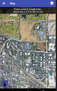
Users can measure fields , parcels or even paths by using the smartphone's GPS sensor. User is able to save the measurement on the device and manage it from the application.
User can also attach camera shots to any path.
Measurements may be modified using the app build in tools for editing functionality.
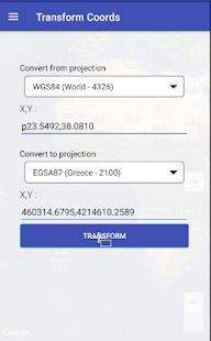
App supports various projections and also offers a build in tool to execute projection transformations among the following projection EPSG codes
-- WGS84 (World - 4326)
-- EGSA87 (Greece - 2100)
-- ED50/UTM zone 30N (Spain - 23030)
-- CGRS93 / Cyprus Local (Cyprus - 6312)
-- WGS 84/Pseudo-Mercator (World - 3857)
-- US National Atlas Equal Area (US - 2163)
-- OSGB 1936/Brit. National (UK - 27700)
-- Amersfoort/RD New (Holland - 28992)
-- ETRS89/LAEA Europe (EU - 3035)
Finally,
measurement may be sent , either as a kml file by email including
camera pictures and a csv file containing measure coordinates or
directly at the gaia service.
App may be used by anyone who
wants to measure plots, fileds, parcels, paths etc regardless of whether
they are subscribers to gaia services or not.
Some screen shots to get the idea. .
No Ads, No Fees !!!!!!! Enjoy.